My wife and I returned tired and weary yesterday from a mammoth road trip from one side of the country to the other.
We went to meet up with one of her cousins and his wife who normally live in Moscow.
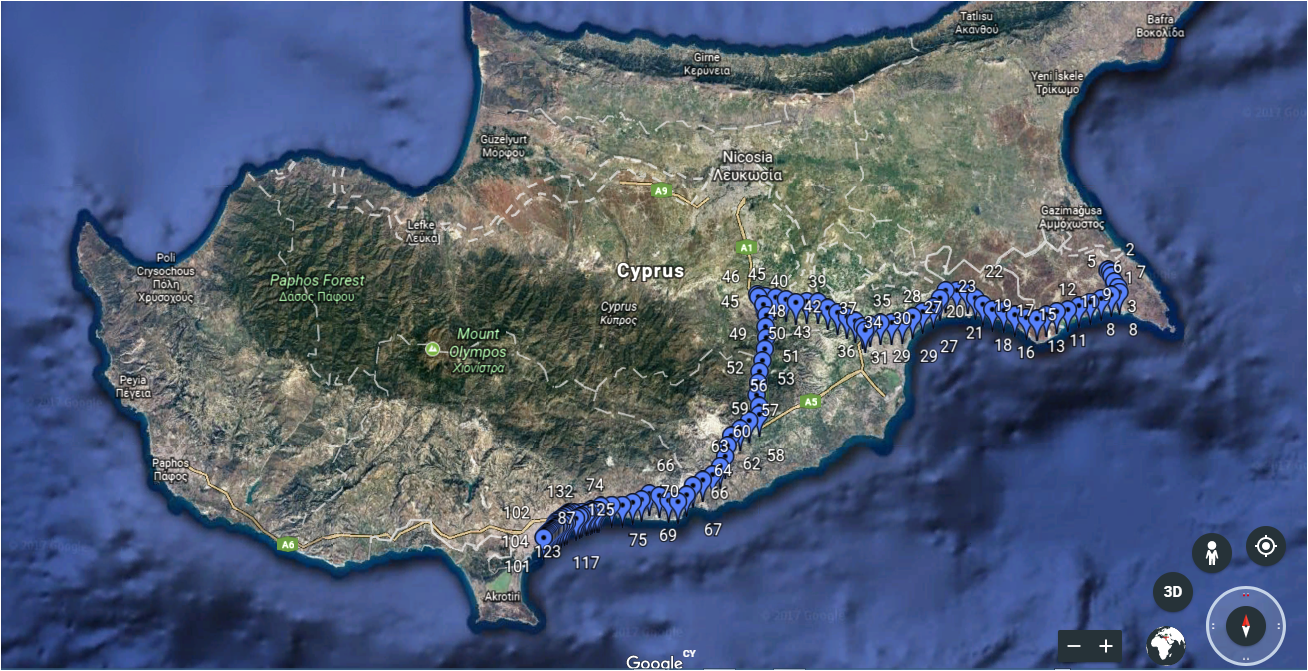
I thought this road trip would be an excellent opportunity to test out the Blynk server running on a Pi ZeroW wireless AP and an external GPS device hooked up to a WeMos.
So everything running locally but accessing the satellites wherever they are located in the atmosphere.
Running everything locally was my first mistake as I searched feverishly for the Blynk data files on our return. Finally I realised the Pi was running with a system date of May rather than August. Must remember to set time and date on the Pi before the next trip or mod the system to use GPS time.
My second mistake was running the WeMos from a databank but running the Pi from the cigarette lighter connection. I realised that if I turned off the engine at any time during the road trip the whole system would go to pot. Pulling the power on a Pi without a formal shutdown is not a good idea. I do have SSH access from my phone to the Pi but it’s too easy to forget to use it if you stop for petrol etc.
We had a scheduled stop to meet up with a friend along the way and the system worked almost flawlessly until this stop. The clock time appears to have jumped back about 8 minutes for one of the minute interval data points. Having stopped and restarted the engine several times during this scheduled stop I disconnected the system for the rest of the journey as I didn’t want to trash the SD card.
The third mistake was simply not remembering the motorway junction exits correctly. So point 34 on the map should have gone South West to point 57 rather than West to point 46 and then South to point 57. Not a major detour but my wife was starting to question my sanity.
I was busy driving @Dmytro so I never got to see whether the Google Map in the Blynk app “followed” us along out trip. Just as we were arriving at our scheduled stop I did manage to see a “slug like” trail on the map. This was caused by all the data points from our efforts driving up and down the main road in search of a particular hotel in “Little Moscow”.
All in all a satisfactory test of the system and we are fortunate that it’s only a couple of hours from one side of the country to the other.
@sh.abar.mard it was done with a Pi Zero W as a local server located in the car but with 3G /4G the server could be anywhere. Physical GPS device was connected to a WeMos and sends the coordinates to the server via Blynk virtualWrite() commands. It updates Blynk’s map widget.
Not sure if it’s this particular project but we have also used Blynk’s webhook widget to send the data directly to a special Google Sheet which is Google Earth compliant. It’s actually quite cool.
When I arrived home I pulled down the csv file and pasted into our online Google Earth compliant Google Sheet.
3G / 4G costs a small fortune here but when we are in the office we can send direct from Blynk to the Google Sheet. There is one manual operation of something like convert to tsv format and then it runs in Google Earth.