Tq sir for giv me chance…
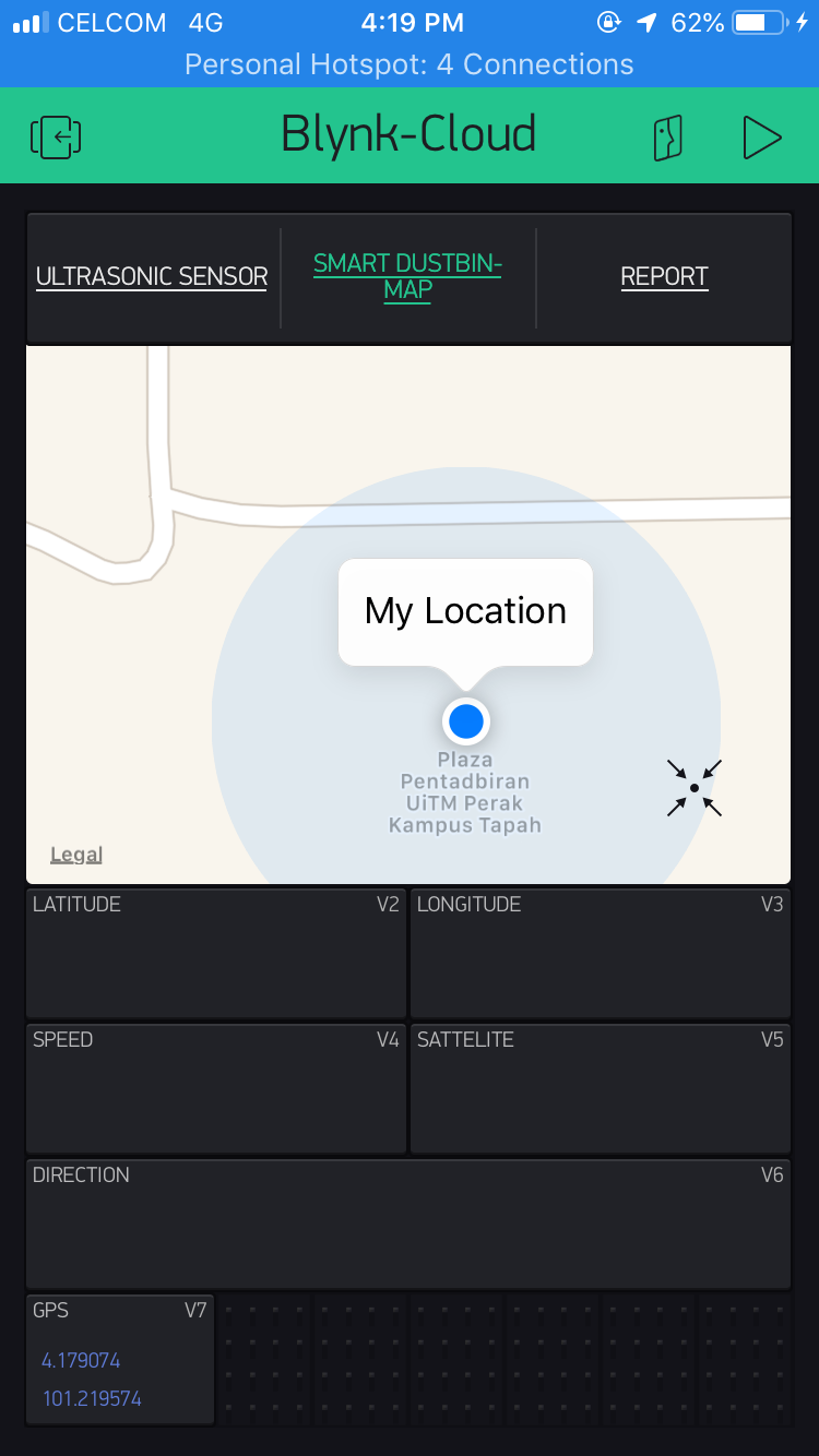
Second Question is i have issue in display latitude, longitude data in blynk app…
Here is the code…
#include <SoftwareSerial.h>
#define BLYNK_PRINT Serial
#include <ESP8266WiFi.h>
#include <BlynkSimpleEsp8266.h>

const int RXPin = 4, TXPin = 5; //GPIO 4=D2(conneect Tx of GPS) and GPIO 5=D1(Connect Rx of GPS
const uint32_t GPSBaud = 4600; //if boud rate 9600 didn't work in your case then use 4600

TinyGPSPlus gps; //the TinyGPS++ object
WidgetMap myMap(V0);
SoftwareSerial ss(RXPin,TXPin); // The serial connection to the GPS device
BlynkTimer timer;

float spd;    // variable to store speed
float sats;   // variable to store no. of satellites response
String bearing; // variable to store orientation or direction of GPS

char auth[] = "xxx";
char ssid[] = "xxx";
char pass[] = "xxxx";

//unsigned int move_index;  //moving index, to be used later
unsigned int move_index = 1;

void setup()
{
  Serial.begin(115200);
  Serial.println();
  ss.begin(GPSBaud);
  Blynk.begin(auth, ssid, pass);
  timer.setInterval(5000L, checkGPS); // every 5s check if GPS is connected, only really needs to be done once
}

void checkGPS()
{
  if (gps.charsProcessed() < 10 )
  {
    Serial.println(F("No GPS detected: check wiring."));
    Blynk.virtualWrite(V5, "GPS ERROR"); // Value display widget on V5 if GPS is not detected
    }
  }

void loop()
{
  while(ss.available() > 0)
  {
    //sketch display information every time a new sentences is correctly encoded
    if (gps.encode(ss.read()))
    displayInfo();
    }
    Blynk.run();
    timer.run();
  }

void displayInfo()
{
  if (gps.location.isValid() )
  {
    float latitude = (gps.location.lat()); // Storing the latitude & logitude
    float longitude = (gps.location.lng());

    Serial.print("LATITUDE: ");
    Serial.println(latitude, 6); // float to x decimal places
    Serial.print("LONGITUDE: ");
    Serial.println(longitude, 6);
    Blynk.virtualWrite(V2, String(latitude, 6));
    Blynk.virtualWrite(V3, String(longitude, 6));
    myMap.location(move_index, latitude, longitude, "GPS_location");
    spd = gps.speed.kmph();
      Blynk.virtualWrite(V4,spd); // get nmumber of speed

      sats = gps.satellites.value(); // get number of satellites
      Blynk.virtualWrite(V5,sats);

      bearing = TinyGPSPlus::cardinal(gps.course.value()); // get the direction
      Blynk.virtualWrite(V6, bearing);
    }
    Serial.println();
  }
It just display like this in my Blynk App… Really beg for u guys help…