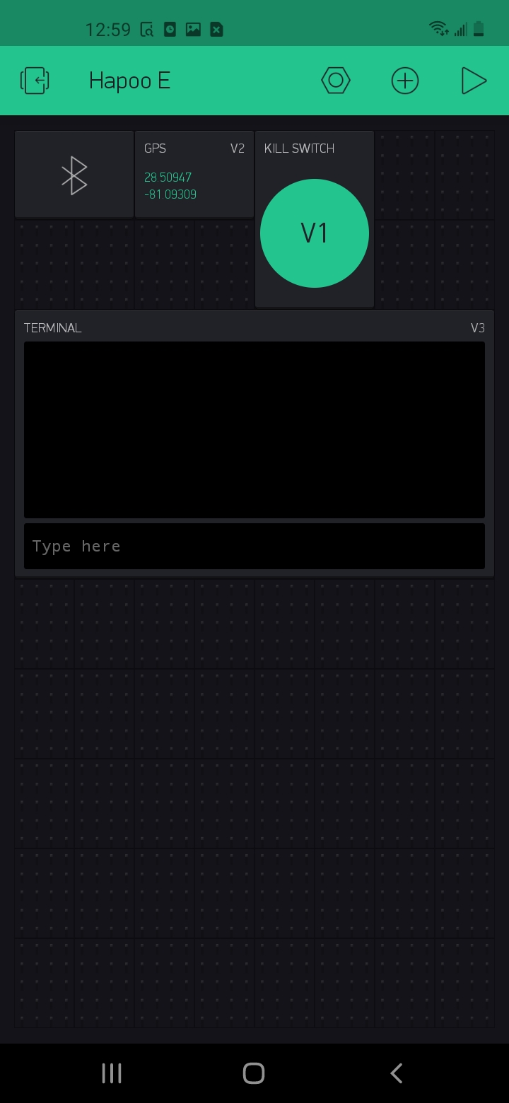
Hi, Pete thanks for reaching out my full code is this. Im new to this so heres my github repository where I put all the code for it Link. I am using a Arduino uno clone called elegoo uno R3. I have added a Bluetooth widget, kill switch, terminal, and gps. heres a screenshot.
#define BLYNK_USE_DIRECT_CONNECT

// Imports
#include <Wire.h>
#include <Adafruit_Sensor.h>
#include <Adafruit_HMC5883_U.h>
#include <Servo.h>
#include <SoftwareSerial.h>
#include <BlynkSimpleSerialBLE.h>
#include "./TinyGPS.h"                 // Use local version of this library
#include "./CoolerDefinitions.h"

// GPS
TinyGPS gps;

// Lid
Servo lidServo;
CoolerLid lidState = CLOSED;

// Master Enable
bool enabled = false;

//WidgetTerminal terminal(V3);

// Serial components
SoftwareSerial bluetoothSerial(BLUETOOTH_TX_PIN, BLUETOOTH_RX_PIN);
SoftwareSerial nss(GPS_TX_PIN, 255);            // TXD to digital pin 6

/* Compass */
Adafruit_HMC5883_Unified mag = Adafruit_HMC5883_Unified(12345);

GeoLoc checkGPS() {
  Serial.println("Reading onboard GPS: ");
  bool newdata = false;
  unsigned long start = millis();
  while (millis() - start < GPS_UPDATE_INTERVAL) {
    if (feedgps())
      newdata = true;
  }
  if (newdata) {
    return gpsdump(gps);
  }

  GeoLoc coolerLoc;
  coolerLoc.lat = 0.0;
  coolerLoc.lon = 0.0;

  return coolerLoc;
}

// Get and process GPS data
GeoLoc gpsdump(TinyGPS &gps) {
  float flat, flon;
  unsigned long age;

  gps.f_get_position(&flat, &flon, &age);

  GeoLoc coolerLoc;
  coolerLoc.lat = flat;
  coolerLoc.lon = flon;

  Serial.print(coolerLoc.lat, 7); Serial.print(", "); Serial.println(coolerLoc.lon, 7);

  return coolerLoc;
}

// Feed data as it becomes available
bool feedgps() {
  while (nss.available()) {
    if (gps.encode(nss.read()))
      return true;
  }
  return false;
}

// Lid Hook
BLYNK_WRITE(V0) {
  switch (lidState) {
    case OPENED:
      setServo(SERVO_LID_CLOSE);
      lidState = CLOSED;
      break;
    case CLOSED:
      setServo(SERVO_LID_OPEN);
      lidState = OPENED;
      break;
  }
}

// Killswitch Hook
BLYNK_WRITE(V1) {
  enabled = !enabled;

  //Stop the wheels
  stop();
}

// GPS Streaming Hook
BLYNK_WRITE(V2) {
  GpsParam gps(param);

  Serial.println("Received remote GPS: ");

  // Print 7 decimal places for Lat
  Serial.print(gps.getLat(), 7); Serial.print(", "); Serial.println(gps.getLon(), 7);

  GeoLoc phoneLoc;
  phoneLoc.lat = gps.getLat();
  phoneLoc.lon = gps.getLon();

  driveTo(phoneLoc, GPS_STREAM_TIMEOUT);
}

// Terminal Hook
BLYNK_WRITE(V3) {
  Serial.print("Received Text: ");
  Serial.println(param.asStr());

  String rawInput(param.asStr());
  int colonIndex;
  int commaIndex;

  do {
    commaIndex = rawInput.indexOf(',');
    colonIndex = rawInput.indexOf(':');

    if (commaIndex != -1) {
      String latStr = rawInput.substring(0, commaIndex);
      String lonStr = rawInput.substring(commaIndex+1);

      if (colonIndex != -1) {
         lonStr = rawInput.substring(commaIndex+1, colonIndex);
      }

      float lat = latStr.toFloat();
      float lon = lonStr.toFloat();

      if (lat != 0 && lon != 0) {
        GeoLoc waypoint;
        waypoint.lat = lat;
        waypoint.lon = lon;

        Serial.print("Waypoint found: "); Serial.print(lat); Serial.println(lon);
        driveTo(waypoint, GPS_WAYPOINT_TIMEOUT);
      }
    }

    rawInput = rawInput.substring(colonIndex + 1);

  } while (colonIndex != -1);
}

void displayCompassDetails(void)
{
  sensor_t sensor;
  mag.getSensor(&sensor);
  Serial.println("------------------------------------");
  Serial.print  ("Sensor:       "); Serial.println(sensor.name);
  Serial.print  ("Driver Ver:   "); Serial.println(sensor.version);
  Serial.print  ("Unique ID:    "); Serial.println(sensor.sensor_id);
  Serial.print  ("Max Value:    "); Serial.print(sensor.max_value); Serial.println(" uT");
  Serial.print  ("Min Value:    "); Serial.print(sensor.min_value); Serial.println(" uT");
  Serial.print  ("Resolution:   "); Serial.print(sensor.resolution); Serial.println(" uT");
  Serial.println("------------------------------------");
  Serial.println("");
  delay(500);
}

#ifndef DEGTORAD
#define DEGTORAD 0.0174532925199432957f
#define RADTODEG 57.295779513082320876f
#endif

float geoBearing(struct GeoLoc &a, struct GeoLoc &b) {
  float y = sin(b.lon-a.lon) * cos(b.lat);
  float x = cos(a.lat)*sin(b.lat) - sin(a.lat)*cos(b.lat)*cos(b.lon-a.lon);
  return atan2(y, x) * RADTODEG;
}

float geoDistance(struct GeoLoc &a, struct GeoLoc &b) {
  const float R = 6371000; // km
  float p1 = a.lat * DEGTORAD;
  float p2 = b.lat * DEGTORAD;
  float dp = (b.lat-a.lat) * DEGTORAD;
  float dl = (b.lon-a.lon) * DEGTORAD;

  float x = sin(dp/2) * sin(dp/2) + cos(p1) * cos(p2) * sin(dl/2) * sin(dl/2);
  float y = 2 * atan2(sqrt(x), sqrt(1-x));

  return R * y;
}

float geoHeading() {
  /* Get a new sensor event */
  sensors_event_t event;
  mag.getEvent(&event);

  // Hold the module so that Z is pointing 'up' and you can measure the heading with x&y
  // Calculate heading when the magnetometer is level, then correct for signs of axis.
  float heading = atan2(event.magnetic.y, event.magnetic.x);

  // Offset
  heading -= DECLINATION_ANGLE;
  heading -= COMPASS_OFFSET;

  // Correct for when signs are reversed.
  if(heading < 0)
    heading += 2*PI;

  // Check for wrap due to addition of declination.
  if(heading > 2*PI)
    heading -= 2*PI;

  // Convert radians to degrees for readability.
  float headingDegrees = heading * 180/M_PI;

  // Map to -180 - 180
  while (headingDegrees < -180) headingDegrees += 360;
  while (headingDegrees >  180) headingDegrees -= 360;

  return headingDegrees;
}

void setServo(int pos) {
  lidServo.attach(SERVO_PIN);
  lidServo.write(pos);
  delay(2000);
  lidServo.detach();
}

void setSpeedMotorA(int speed) {
  digitalWrite(MOTOR_A_IN_1_PIN, LOW);
  digitalWrite(MOTOR_A_IN_2_PIN, HIGH);

  // set speed to 200 out of possible range 0~255
  analogWrite(MOTOR_A_EN_PIN, speed + MOTOR_A_OFFSET);
}

void setSpeedMotorB(int speed) {
  digitalWrite(MOTOR_B_IN_1_PIN, LOW);
  digitalWrite(MOTOR_B_IN_2_PIN, HIGH);

  // set speed to 200 out of possible range 0~255
  analogWrite(MOTOR_B_EN_PIN, speed + MOTOR_B_OFFSET);
}

void setSpeed(int speed)
{
  // this function will run the motors in both directions at a fixed speed
  // turn on motor A
  setSpeedMotorA(speed);

  // turn on motor B
  setSpeedMotorB(speed);
}

void stop() {
  // now turn off motors
  digitalWrite(MOTOR_A_IN_1_PIN, LOW);
  digitalWrite(MOTOR_A_IN_2_PIN, LOW);
  digitalWrite(MOTOR_B_IN_1_PIN, LOW);
  digitalWrite(MOTOR_B_IN_2_PIN, LOW);
}

void drive(int distance, float turn) {
  int fullSpeed = 230;
  int stopSpeed = 0;

  // drive to location
  int s = fullSpeed;
  if ( distance < 8 ) {
    int wouldBeSpeed = s - stopSpeed;
    wouldBeSpeed *= distance / 8.0f;
    s = stopSpeed + wouldBeSpeed;
  }

  int autoThrottle = constrain(s, stopSpeed, fullSpeed);
  autoThrottle = 230;

  float t = turn;
  while (t < -180) t += 360;
  while (t >  180) t -= 360;

  Serial.print("turn: ");
  Serial.println(t);
  Serial.print("original: ");
  Serial.println(turn);

  float t_modifier = (180.0 - abs(t)) / 180.0;
  float autoSteerA = 1;
  float autoSteerB = 1;

  if (t < 0) {
    autoSteerB = t_modifier;
  } else if (t > 0){
    autoSteerA = t_modifier;
  }

  Serial.print("steerA: "); Serial.println(autoSteerA);
  Serial.print("steerB: "); Serial.println(autoSteerB);

  int speedA = (int) (((float) autoThrottle) * autoSteerA);
  int speedB = (int) (((float) autoThrottle) * autoSteerB);

  setSpeedMotorA(speedA);
  setSpeedMotorB(speedB);
}

void driveTo(struct GeoLoc &loc, int timeout) {
  nss.listen();
  GeoLoc coolerLoc = checkGPS();
  bluetoothSerial.listen();

  if (coolerLoc.lat != 0 && coolerLoc.lon != 0 && enabled) {
    float d = 0;
    //Start move loop here
    do {
      nss.listen();
      coolerLoc = checkGPS();
      bluetoothSerial.listen();

      d = geoDistance(coolerLoc, loc);
      float t = geoBearing(coolerLoc, loc) - geoHeading();

      Serial.print("Distance: ");
      Serial.println(geoDistance(coolerLoc, loc));

      Serial.print("Bearing: ");
      Serial.println(geoBearing(coolerLoc, loc));

      Serial.print("heading: ");
      Serial.println(geoHeading());

      drive(d, t);
      timeout -= 1;
    } while (d > 3.0 && enabled && timeout>0);

    stop();
  }
}

void setupCompass() {
   /* Initialise the compass */
  if(!mag.begin())
  {
    /* There was a problem detecting the HMC5883 ... check your connections */
    Serial.println("Ooops, no HMC5883 detected ... Check your wiring!");
    while(1);
  }

  /* Display some basic information on this sensor */
  displayCompassDetails();
}

void setup()
{
  // Compass
  setupCompass();

  // Motor pins
  pinMode(MOTOR_A_EN_PIN, OUTPUT);
  pinMode(MOTOR_B_EN_PIN, OUTPUT);
  pinMode(MOTOR_A_IN_1_PIN, OUTPUT);
  pinMode(MOTOR_A_IN_2_PIN, OUTPUT);
  pinMode(MOTOR_B_IN_1_PIN, OUTPUT);
  pinMode(MOTOR_B_IN_2_PIN, OUTPUT);

  pinMode(LED_BUILTIN, OUTPUT);
  digitalWrite(LED_BUILTIN, HIGH);

  //Debugging via serial
  Serial.begin(4800);

  //GPS
  nss.begin(9600);

  //Bluetooth
  bluetoothSerial.begin(38400);
  Blynk.begin(bluetoothSerial, auth);
}

// Testing
void testDriveNorth() {
  float heading = geoHeading();
  int testDist = 10;
  Serial.println(heading);

  while(!(heading < 5 && heading > -5)) {
    drive(testDist, heading);
    heading = geoHeading();
    Serial.println(heading);
    delay(500);
  }

  stop();
}

void loop()
{
  Blynk.run();
}
// Blynk Auth
char auth[] = "FxwInNKuU9p2dmTzOpDkMxrkysB6QIg1";

// Pin variables
#define SERVO_PIN 3

#define GPS_TX_PIN 4
#define GPS_RX_PIN 3

#define BLUETOOTH_TX_PIN 10
#define BLUETOOTH_RX_PIN 11

#define MOTOR_A_EN_PIN 5
#define MOTOR_B_EN_PIN 9
#define MOTOR_A_IN_1_PIN 7
#define MOTOR_A_IN_2_PIN 8
#define MOTOR_B_IN_1_PIN 12
#define MOTOR_B_IN_2_PIN 6

// If one motor tends to spin faster than the other, add offset
#define MOTOR_A_OFFSET 10
#define MOTOR_B_OFFSET 10

// You must then add your 'Declination Angle' to the compass, which is the 'Error' of the magnetic field in your location.
// Find yours here: http://www.magnetic-declination.com/
// Mine is: 13° 24' E (Positive), which is ~13 Degrees, or (which we need) 0.23 radians
#define DECLINATION_ANGLE 0.10f

// The offset of the mounting position to true north
// It would be best to run the /examples/magsensor sketch and compare to the compass on your smartphone
#define COMPASS_OFFSET 0.0f

// How often the GPS should update in MS
// Keep this above 1000
#define GPS_UPDATE_INTERVAL 1000

// Number of changes in movement to timeout for GPS streaming
// Keeps the cooler from driving away if there is a problem
#define GPS_STREAM_TIMEOUT 18

// Number of changes in movement to timeout for GPS waypoints
// Keeps the cooler from driving away if there is a problem
#define GPS_WAYPOINT_TIMEOUT 45

// PWM write for servo locations
#define SERVO_LID_OPEN 20
#define SERVO_LID_CLOSE 165

// Definitions (don't edit these)
struct GeoLoc {
  float lat;
  float lon;
};

enum CoolerLid {
  OPENED,
  CLOSED
};
#include "Arduino.h"
#include "TinyGPS.h"

#define _GPRMC_TERM   "GPRMC"
#define _GPGGA_TERM   "GPGGA"

TinyGPS::TinyGPS()
:  _time(GPS_INVALID_TIME)
,  _date(GPS_INVALID_DATE)
,  _latitude(GPS_INVALID_ANGLE)
,  _longitude(GPS_INVALID_ANGLE)
,  _altitude(GPS_INVALID_ALTITUDE)
,  _speed(GPS_INVALID_SPEED)
,  _course(GPS_INVALID_ANGLE)
,  _last_time_fix(GPS_INVALID_FIX_TIME)
,  _last_position_fix(GPS_INVALID_FIX_TIME)
,  _parity(0)
,  _is_checksum_term(false)
,  _sentence_type(_GPS_SENTENCE_OTHER)
,  _term_number(0)
,  _term_offset(0)
,  _gps_data_good(false)
#ifndef _GPS_NO_STATS
,  _encoded_characters(0)
,  _good_sentences(0)
,  _failed_checksum(0)
#endif
{
  _term[0] = '\0';
}

//
// public methods
//

bool TinyGPS::encode(char c)
{
  bool valid_sentence = false;

  ++_encoded_characters;
  switch(c)
  {
  case ',': // term terminators
    _parity ^= c;
  case '\r':
  case '\n':
  case '*':
    if (_term_offset < sizeof(_term))
    {
      _term[_term_offset] = 0;
      valid_sentence = term_complete();
    }
    ++_term_number;
    _term_offset = 0;
    _is_checksum_term = c == '*';
    return valid_sentence;

  case '$': // sentence begin
    _term_number = _term_offset = 0;
    _parity = 0;
    _sentence_type = _GPS_SENTENCE_OTHER;
    _is_checksum_term = false;
    _gps_data_good = false;
    return valid_sentence;
  }

  // ordinary characters
  if (_term_offset < sizeof(_term) - 1)
    _term[_term_offset++] = c;
  if (!_is_checksum_term)
    _parity ^= c;

  return valid_sentence;
}

#ifndef _GPS_NO_STATS
void TinyGPS::stats(unsigned long *chars, unsigned short *sentences, unsigned short *failed_cs)
{
  if (chars) *chars = _encoded_characters;
  if (sentences) *sentences = _good_sentences;
  if (failed_cs) *failed_cs = _failed_checksum;
}
#endif

//
// internal utilities
//
int TinyGPS::from_hex(char a)
{
  if (a >= 'A' && a <= 'F')
    return a - 'A' + 10;
  else if (a >= 'a' && a <= 'f')
    return a - 'a' + 10;
  else
    return a - '0';
}

unsigned long TinyGPS::parse_decimal()
{
  char *p = _term;
  bool isneg = *p == '-';
  if (isneg) ++p;
  unsigned long ret = 100UL * gpsatol(p);
  while (gpsisdigit(*p)) ++p;
  if (*p == '.')
  {
    if (gpsisdigit(p[1]))
    {
      ret += 10 * (p[1] - '0');
      if (gpsisdigit(p[2]))
        ret += p[2] - '0';
    }
  }
  return isneg ? -ret : ret;
}

unsigned long TinyGPS::parse_degrees()
{
  char *p;
  unsigned long left = gpsatol(_term);
  unsigned long tenk_minutes = (left % 100UL) * 10000UL;
  for (p=_term; gpsisdigit(*p); ++p);
  if (*p == '.')
  {
    unsigned long mult = 1000;
    while (gpsisdigit(*++p))
    {
      tenk_minutes += mult * (*p - '0');
      mult /= 10;
    }
  }
  return (left / 100) * 100000 + tenk_minutes / 6;
}

// Processes a just-completed term
// Returns true if new sentence has just passed checksum test and is validated
bool TinyGPS::term_complete()
{
  if (_is_checksum_term)
  {
    byte checksum = 16 * from_hex(_term[0]) + from_hex(_term[1]);
    if (checksum == _parity)
    {
      if (_gps_data_good)
      {
#ifndef _GPS_NO_STATS
        ++_good_sentences;
#endif
        _last_time_fix = _new_time_fix;
        _last_position_fix = _new_position_fix;

        switch(_sentence_type)
        {
        case _GPS_SENTENCE_GPRMC:
          _time      = _new_time;
          _date      = _new_date;
          _latitude  = _new_latitude;
          _longitude = _new_longitude;
          _speed     = _new_speed;
          _course    = _new_course;
          break;
        case _GPS_SENTENCE_GPGGA:
          _altitude  = _new_altitude;
          _time      = _new_time;
          _latitude  = _new_latitude;
          _longitude = _new_longitude;
          break;
        }

        return true;
      }
    }

#ifndef _GPS_NO_STATS
    else
      ++_failed_checksum;
#endif
    return false;
  }

  // the first term determines the sentence type
  if (_term_number == 0)
  {
    if (!gpsstrcmp(_term, _GPRMC_TERM))
      _sentence_type = _GPS_SENTENCE_GPRMC;
    else if (!gpsstrcmp(_term, _GPGGA_TERM))
      _sentence_type = _GPS_SENTENCE_GPGGA;
    else
      _sentence_type = _GPS_SENTENCE_OTHER;
    return false;
  }

  if (_sentence_type != _GPS_SENTENCE_OTHER && _term[0])
  switch((_sentence_type == _GPS_SENTENCE_GPGGA ? 200 : 100) + _term_number)
  {
    case 101: // Time in both sentences
    case 201:
      _new_time = parse_decimal();
      _new_time_fix = millis();
      break;
    case 102: // GPRMC validity
      _gps_data_good = _term[0] == 'A';
      break;
    case 103: // Latitude
    case 202:
      _new_latitude = parse_degrees();
      _new_position_fix = millis();
      break;
    case 104: // N/S
    case 203:
      if (_term[0] == 'S')
        _new_latitude = -_new_latitude;
      break;
    case 105: // Longitude
    case 204:
      _new_longitude = parse_degrees();
      break;
    case 106: // E/W
    case 205:
      if (_term[0] == 'W')
        _new_longitude = -_new_longitude;
      break;
    case 107: // Speed (GPRMC)
      _new_speed = parse_decimal();
      break;
    case 108: // Course (GPRMC)
      _new_course = parse_decimal();
      break;
    case 109: // Date (GPRMC)
      _new_date = gpsatol(_term);
      break;
    case 206: // Fix data (GPGGA)
      _gps_data_good = _term[0] > '0';
      break;
    case 209: // Altitude (GPGGA)
      _new_altitude = parse_decimal();
      break;
  }

  return false;
}

long TinyGPS::gpsatol(const char *str)
{
  long ret = 0;
  while (gpsisdigit(*str))
    ret = 10 * ret + *str++ - '0';
  return ret;
}

int TinyGPS::gpsstrcmp(const char *str1, const char *str2)
{
  while (*str1 && *str1 == *str2)
    ++str1, ++str2;
  return *str1;
}

/* static */
float TinyGPS::distance_between (float lat1, float long1, float lat2, float long2)
{
  // returns distance in meters between two positions, both specified
  // as signed decimal-degrees latitude and longitude. Uses great-circle
  // distance computation for hypothetical sphere of radius 6372795 meters.
  // Because Earth is no exact sphere, rounding errors may be up to 0.5%.
  // Courtesy of Maarten Lamers
  float delta = radians(long1-long2);
  float sdlong = sin(delta);
  float cdlong = cos(delta);
  lat1 = radians(lat1);
  lat2 = radians(lat2);
  float slat1 = sin(lat1);
  float clat1 = cos(lat1);
  float slat2 = sin(lat2);
  float clat2 = cos(lat2);
  delta = (clat1 * slat2) - (slat1 * clat2 * cdlong);
  delta = sq(delta);
  delta += sq(clat2 * sdlong);
  delta = sqrt(delta);
  float denom = (slat1 * slat2) + (clat1 * clat2 * cdlong);
  delta = atan2(delta, denom);
  return delta * 6372795;
}
#ifndef TinyGPS_h
#define TinyGPS_h

#include "Arduino.h"

#define _GPS_VERSION 10 // software version of this library
#define _GPS_MPH_PER_KNOT 1.15077945
#define _GPS_MPS_PER_KNOT 0.51444444
#define _GPS_KMPH_PER_KNOT 1.852
#define _GPS_MILES_PER_METER 0.00062137112
#define _GPS_KM_PER_METER 0.001
//#define _GPS_NO_STATS

class TinyGPS
{
  public:
    TinyGPS();
    bool encode(char c); // process one character received from GPS
    TinyGPS &operator << (char c) {encode(c); return *this;}

    // lat/long in hundred thousandths of a degree and age of fix in milliseconds
    inline void get_position(long *latitude, long *longitude, unsigned long *fix_age = 0)
    {
      if (latitude) *latitude = _latitude;
      if (longitude) *longitude = _longitude;
      if (fix_age) *fix_age = _last_position_fix == GPS_INVALID_FIX_TIME ?
        GPS_INVALID_AGE : millis() - _last_position_fix;
    }

    // date as ddmmyy, time as hhmmsscc, and age in milliseconds
    inline void get_datetime(unsigned long *date, unsigned long *time, unsigned long *fix_age = 0)
    {
      if (date) *date = _date;
      if (time) *time = _time;
      if (fix_age) *fix_age = _last_time_fix == GPS_INVALID_FIX_TIME ?
        GPS_INVALID_AGE : millis() - _last_time_fix;
    }

    // signed altitude in centimeters (from GPGGA sentence)
    inline long altitude() { return _altitude; }

    // course in last full GPRMC sentence in 100th of a degree
    inline unsigned long course() { return _course; }

    // speed in last full GPRMC sentence in 100ths of a knot
    unsigned long speed() { return _speed; }

#ifndef _GPS_NO_STATS
    void stats(unsigned long *chars, unsigned short *good_sentences, unsigned short *failed_cs);
#endif

    inline void f_get_position(float *latitude, float *longitude, unsigned long *fix_age = 0)
    {
      long lat, lon;
      get_position(&lat, &lon, fix_age);
      *latitude = lat / 100000.0;
      *longitude = lon / 100000.0;
    }

    inline void crack_datetime(int *year, byte *month, byte *day,
      byte *hour, byte *minute, byte *second, byte *hundredths = 0, unsigned long *fix_age = 0)
    {
      unsigned long date, time;
      get_datetime(&date, &time, fix_age);
      if (year)
      {
        *year = date % 100;
        *year += *year > 80 ? 1900 : 2000;
      }
      if (month) *month = (date / 100) % 100;
      if (day) *day = date / 10000;
      if (hour) *hour = time / 1000000;
      if (minute) *minute = (time / 10000) % 100;
      if (second) *second = (time / 100) % 100;
      if (hundredths) *hundredths = time % 100;
    }

    inline float f_altitude()    { return altitude() / 100.0; }
    inline float f_course()      { return course() / 100.0; }
    inline float f_speed_knots() { return speed() / 100.0; }
    inline float f_speed_mph()   { return _GPS_MPH_PER_KNOT * f_speed_knots(); }
    inline float f_speed_mps()   { return _GPS_MPS_PER_KNOT * f_speed_knots(); }
    inline float f_speed_kmph()  { return _GPS_KMPH_PER_KNOT * f_speed_knots(); }

    static int library_version() { return _GPS_VERSION; }

    enum {GPS_INVALID_AGE = 0xFFFFFFFF, GPS_INVALID_ANGLE = 999999999, GPS_INVALID_ALTITUDE = 999999999, GPS_INVALID_DATE = 0,
      GPS_INVALID_TIME = 0xFFFFFFFF, GPS_INVALID_SPEED = 999999999, GPS_INVALID_FIX_TIME = 0xFFFFFFFF};


    static float distance_between (float lat1, float long1, float lat2, float long2);

private:
    enum {_GPS_SENTENCE_GPGGA, _GPS_SENTENCE_GPRMC, _GPS_SENTENCE_OTHER};

    // properties
    unsigned long _time, _new_time;
    unsigned long _date, _new_date;
    long _latitude, _new_latitude;
    long _longitude, _new_longitude;
    long _altitude, _new_altitude;
    unsigned long  _speed, _new_speed;
    unsigned long  _course, _new_course;

    unsigned long _last_time_fix, _new_time_fix;
    unsigned long _last_position_fix, _new_position_fix;

    // parsing state variables
    byte _parity;
    bool _is_checksum_term;
    char _term[15];
    byte _sentence_type;
    byte _term_number;
    byte _term_offset;
    bool _gps_data_good;

#ifndef _GPS_NO_STATS
    // statistics
    unsigned long _encoded_characters;
    unsigned short _good_sentences;
    unsigned short _failed_checksum;
    unsigned short _passed_checksum;
#endif

    // internal utilities
    int from_hex(char a);
    unsigned long parse_decimal();
    unsigned long parse_degrees();
    bool term_complete();
    bool gpsisdigit(char c) { return c >= '0' && c <= '9'; }
    long gpsatol(const char *str);
    int gpsstrcmp(const char *str1, const char *str2);
};

// Arduino 0012 workaround
#undef int
#undef char
#undef long
#undef byte
#undef float
#undef abs
#undef round

#endif